

This is the list of Historical Markers for Mason County, West Virginia. There are thirty-two noted in the WV Memory Project database. Of those thirty-two, eight are missing. The database lists two signs as one at times. I will determine, as I see them in person, if this is due to different inscriptions on either side of the sign. Commonly, the sign has duplicate information printed on each side.
Some of the missing ones have duplicate information. Some of those signs will have a singular blog or be added to the blog of another marker with similar data.
Title: Cabell County/Mason County
Blog Link: Coming Soon
Although no longer standing, there are a number of archived images I can usually find for the missing markers. That was not the case with this marker. If you have a picture of this marker, I would love to include it with the blog.
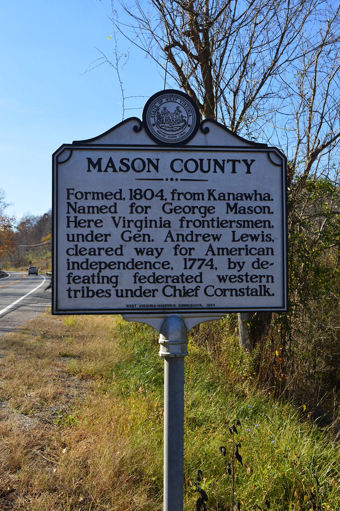
Inscription: Formed, 1804, from Kanawha. Named for George Mason. Here Virginia frontiersmen, under Gen. Andrew Lewis, cleared way for American independence, 1774, by defeating federated western tribes under Chief Cornstalk. Formed, 1809, from Kanawha. Originally included several of the present counties of West Virginia. Named for William H. Cabell, Virginia governor, 1805-08. Big Sandy River was the western end of the James River and Kanawha Turnpike.
Location: WV 2 (missing)
Title: Mason County/West Virginia
Blog Link: Coming Soon
Although no longer standing, there are a number of archived images I can usually find for the missing markers. That was not the case with this marker. If you have a picture of this marker, I would love to include it with the blog.
Inscription: Formed, 1804, from Kanawha. Named for George Mason. Here Virginia frontiersmen, under Gen. Andrew Lewis, cleared way for American independence, 1774, by defeating federated western tribes under Chief Cornstalk. “The Mountain State”–western part of the Commonwealth of Virginia until June 20, 1863. Settled by the Germans and Scotch-Irish. It became a line of defense between the English and French during the French and Indian War.
Location: Mason City, US 33 and WV 62 (missing)
Title: “Mark Twain” Family
Blog Link: https://seletyn.com/2020/01/12/wv-history-grandparents-of-mark-twain/

Inscription: Samuel and Pamela Clemens, grandparents of “Mark Twain”, settled here in 1803. Samuel was accidently killed in 1805 at a “house-raising”. Their eldest son, John Marshall, the father of “Mark Twain”, lived here until he moved West.
Location: WV 62, Lakin
Title: Fort Robinson
Blog Link: Coming Soon

Inscription: Near here stood the blockhouse built by Captain Isaac Robinson in 1794. Indians attacked the fort soon after its erection but the little garrison drove them away. Robinson spent 12 years as an Indian captive and was a noted border scout.
Location: WV 62 north of Pt. Pleasant
Title: Gen. John McCausland
Blog Link: Coming Soon

Inscription: On pinnacle (300 feet E.) overlooking his boyhood home is the grave of Gen. John McCausland, 1836-1927. He was conspicuous for his operations in the Shenandoah Valley, and for his raids into Maryland and Pennsylvania. He fought at Petersburg and Five Forks and on the retreat to Appomattox, cut his way through Federal lines before the surrender. Paroled at Charleston, West Virginia at close of the War.
Location: WV 2, below cemetery at Henderson (missing)
This is listed two times in the database??
Title: Gen. John McCausland
Blog Link: Coming Soon
Inscription: On pinnacle (300 feet E.) overlooking his boyhood home is the grave of Gen. John McCausland, 1836-1927. He was conspicuous for his operations in the Shenandoah Valley, and for his raids into Maryland and Pennsylvania. He fought at Petersburg and Five Forks and on the retreat to Appomattox, cut his way through Federal lines before the surrender. Paroled at Charleston, West Virginia at close of the War.
Location: WV 2, below cemetery at Henderson (missing)
This is listed two times in the database??
Title: Harmony Baptist Church
Blog Link: Coming Soon
Although no longer standing, there are a number of archived images I can usually find for the missing markers. That was not the case with this marker. If you have a picture of this marker, I would love to include it with the blog.
Inscription: The Reverend William George and sixteen charter members organized the Harmony Baptist Church in 1812. Congregation, affiliated with American Baptist churches, met in the Sullivan Meeting House from 1838-60. After 1842, meetings alternated with Harmony Meeting House. Present sanctuary was the original church built and dedicated in 1860.
Location: US 35, 15 miles south of Pt. Pleasant (missing)
Title: May Moore Mound
Blog Link: Coming Soon

Inscription: This is one of the larger burial mounds in the State. It has never been properly excavated, but was probably built by the Adena people between 500 B.C. and A.D. 1. Several smaller mounds can also be seen in this area.
Location: WV 2, 2 miles north of Ben Lomand
Title: Mercer’s Bottom/Captain John Hereford
Blog Link: Coming Soon

Inscription: This is part of the 16,000 acre tract surveyed by order of Washington for General Hugh Mercer. Nearby are the graves of Adjutant John Hereford and Ensign John Wilson. They were officers in the Revolutionary Army.

Revolutionary War Adjutant in Col. John Alexander’s Virginia Regiment under Lafayette at Yorktown. He was born in Fairfax Co. in 1758, moved to Mason Co. in 1808, serving as magistrate and sheriff, and died, 1846.
Location: WV 2, north of Ashton
Title: Thomas Hannan
Blog Link: Coming Soon

Inscription: Born 1755, died 1835. Soldier in the Revolution and the first white settler in Cabell County. Blazed trace from Saint Albans to Chillicothe which bears his name. This was the first road that came into Cabell and Mason Counties. Hannan owned 5800 acres of land in these counties. He is buried in private cemetery nearby.
Location: WV 2, just north of Cabell County line
Title: Andrew & Charles Lewis March
Blog Link: Coming Soon

Inscription: The nearby highway is part of route traversing W. Va. from Lewisburg to Point Pleasant memorialized by the state to commemorate the march of the American Colonial army of 1,200 men led by Andrew & Charles Lewis. After a month’s march this army defeated a Shawnee Indian force led by Cornstalk at the Battle of Point Pleasant on the banks of the Ohio & Kanawha rivers, October 10, 1774.
Location: east of Pt. Pleasant, east part of Krodel Park, 2.1 miles west of WV 2/WV 62 split
Title: Boone’s Trading Post
Blog Link: Coming Soon

Inscription: Daniel Boone, noted scout and Indian fighter, operated trading post here, 1790. He was scout for General Lewis enroute to Point Pleasant, 1774. Named County Lieutenant for Kanawha and served this county in the Virginia Assembly.
Location: east of Pt. Pleasant near west entrance of Krodel Park, 2.5 miles west of WV 2/WV 62 split
Title: Dr. Jesse Bennett
Blog Link: Coming Soon
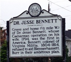
Inscription: Grave and home (1/2 mile W.) of Dr. Jesse Bennett, whose Caesarean operation on his wife, 1794, was the first in America. Bennett, colonel of Virginia Militia, 1804-1814, refused to aid Blennerhassett, Burr in their ambitious plan.
Location: Pt. Pleasant, Wv 62 and 9th Street, 0.3 miles north of WV 25
Title: Lakin State Hospital
Blog Link: Coming Soon
Although no longer standing, there are a number of archived images I can usually find for the missing markers. That was not the case with this marker. If you have a picture of this marker, I would love to include it with the blog.
Inscription: Established in 1919 by an act of the Legislature. Opened for colored patients in 1926 and integrated in 1954. In 1957, the Hospital acquired the former Boys Industrial School. A rehabilitation center has since been added to the Hospital.
Location: WV 62, 8.4 miles north of WV 2 (missing)
Title: Virgil A. Lewis
Blog Link: Coming Soon

Inscription: Educator and historian born near West Columbia, July 6, 1848; died in Mason City, December 5, 1912; was buried in Point Pleasant. He founded the Southern Historical Magazine in 1892; was State Superintendent of Schools, 1893-97; first State Historian and Archivist, 1905-12; author of many books. How West Virginia Was Made, History and Government of West Virginia, and Hand Book of West Virginia are among the best known.
Location: Mason City, US 33 and Brown Street, 0.6 miles north of WV 62
Title: George Rogers Clark
Blog Link: https://seletyn.com/2020/02/03/historical-marker-geroge-rogers-clark/

Inscription: From the Kanawha’s mouth in May, 1778, George Rogers Clark set out to attack the British at Vincennes and Kaskaskia. The conquest of the Northwest by his little army of 175 men is ranked among the greatest exploits of all history.”
Location: Point Pleasant Courthouse Square, WV 2 and 6th Street, 0.1 miles south of WV 62
Title: Point Pleasant
Blog Link: Coming Soon

Inscription: Fort Blair was built here in 1774 and later Fort Randolph, the center of Indian activities, 1777-1778. Here are graves of “Mad Anne” Bailey, border scout, and Cornstalk, Shawnee chief, held hostage and killed here in 1777.
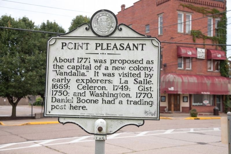
About 1771 was proposed as the capital of a new colony, “Vandalia.” It was visited by early explorers: La Salle, 1669; Celeron, 1749; Gist, 1750; and Washington, 1770. Daniel Boone had a trading post here.
Location: Point Pleasant Courthouse Square, WV 2 and 6th Street, 0.1 miles west of WV 62
Title: “Border Grays”
Blog Link: Coming Soon

Inscription: Organized at Barboursville, Sept. 18, 1862, with Captain William Gunn as commander. Served with the Guyandotte Battalion until Jan. 1863, then was assigned as Company D, 8th Virginia Cavalry, CSA, under Col. Albert G. Jenkins.
Location: Point Pleasant, 4th Street off WV 2 0.2 miles south of WV 62
Title: Point Pleasant Battle/War of 1812
Blog Link: Coming Soon

Inscription: Here Oct. 10, 1774, General Andrew Lewis and a thousand Virginia riflemen defeated the federated Indian tribes led by Cornstalk. Known as the “first battle of the Revolution.” It was the most important battle between Indians and whites.

On October 20, 1812, the western Virginia Brigade of Militia under command of General Joel Leftwich, embarked here for the Ohio frontier to join the Northwestern Army for service in the Second War with England.
Location: Point Pleasant Battle Monument Park off WV 2, 0.4 miles south of WV 62 at Main and 1st streets
Title: “Lost Colony”
Blog Link: Coming Soon

Inscription: In 1772, Washington patented 10,990 acres along the Great Kanawha River. In 1775, he had James Cleveland and William Stevens lead colonist there. Land was cleared; orchards planted, houses built. But when war ended, colony was gone.
Location: US 35, Southside, 8.8 miles east of WV 2
Title: General McCausland
Blog Link: Coming Soon
Inscription: Home of General John McCausland, 1836-1927, one of the last officers of the general staff of the Confederate Army. He served in Pennsylvania, the Virginias, and Maryland. He led Lomax’s cavalry against Sheridan in Valley Campaign.
Location: US 35, 17.1 miles south of WV 2, 0.4 miles west of Putnam County border
Title: Early Graves
Blog Link: Coming Soon
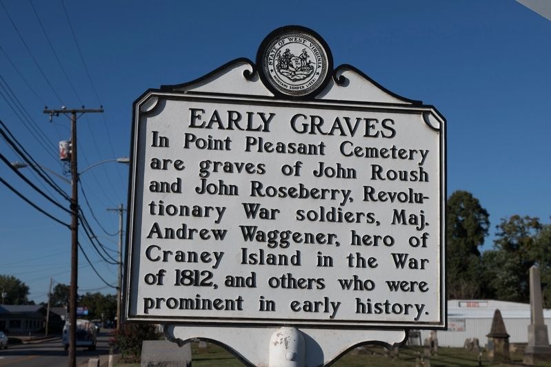
Inscription: In Point Pleasant Cemetery are graves of John Roush and John Roseberry, Revolutionary War soldiers, Maj. Andrew Waggener, hero of Craney Island in the War of 1812, and others who were prominent in early history.
Location: Point Pleasant, WV 62 and 9th Street, 0.3 miles north of WV 25
Title: Jackson County/Mason County
Blog Link: Coming Soon
Inscription: Formed in 1831 from Kanawha, Mason, and Wood. Named for General Andrew Jackson, the seventh President of the United States. Jesse Hughes, noted Indian fighter, spent his declining years in the county where he is buried.Formed, 1804, from Kanawha. Named for George Mason. Here Virginia frontiersmen, under Gen. Andrew Lewis, cleared way for American independence, 1774, by defeating federated western tribes under Chief Cornstalk.
Location: WV 2
Title: Jackson County/Mason County
Blog Link: Coming Soon
Inscription: Formed in 1831 from Kanawha, Mason, and Wood. Named for General Andrew Jackson, the seventh President of the United States. Jesse Hughes, noted Indian fighter, spent his declining years in the county where he is buried.Formed, 1804, from Kanawha. Named for George Mason. Here Virginia frontiersmen, under Gen. Andrew Lewis, cleared way for American independence, 1774, by defeating federated western tribes under Chief Cornstalk.
Location: US 33 (missing)
Title: Mason County/Putnam County
Blog Link: Coming Soon
Although no longer standing, there are a number of archived images I can usually find for the missing markers. That was not the case with this marker. If you have a picture of this marker, I would love to include it with the blog.
Inscription: Formed, 1804, from Kanawha. Named for George Mason. Here Virginia frontiersmen, under Gen. Andrew Lewis, cleared way for American independence, 1774, by defeating federated western tribes under Chief Cornstalk.Formed in 1848 from Cabell, Mason and Kanawha. Named for Gen. Israel Putnam, a Revolutionary War hero. The county is cut by trails made by American bison to the Ohio River. Its oldest town, Buffalo, is named for them.
Location: US 35 (missing)
Title: Mason County/Putnam County
Blog Link: Coming Soon
Although no longer standing, there are a number of archived images I can usually find for the missing markers. That was not the case with this marker. If you have a picture of this marker, I would love to include it with the blog.
Inscription: Formed, 1804, from Kanawha. Named for George Mason. Here Virginia frontiersmen, under Gen. Andrew Lewis, cleared way for American independence, 1774, by defeating federated western tribes under Chief Cornstalk.Formed in 1848 from Cabell, Mason and Kanawha. Named for Gen. Israel Putnam, a Revolutionary War hero. The county is cut by trails made by American bison to the Ohio River. Its oldest town, Buffalo, is named for them.
Location: WV 62 (missing)
Title: West Virginia (Mason County)/Ohio
Blog Link: Coming Soon

Inscription: “The Mountain State”–western part of the Commonwealth of Virginia until June 20, 1863. Settled by the Germans and Scotch-Irish. It became a line of defense between the English and French during the French and Indian War, 1754-1763.Named for the river, called by the Iroquois the “Beautiful River.” Visited by LaSalle in 1769-1770. Once part of the Northwest Territory. Settled at Marietta, 1788. Admitted to the Union, 1803. Home of 8 United States Presidents.
Location: 6th Street, at junction with Main Street, county courthouse, Point Pleasant
Title: Livia S. Poffenbarger
Blog Link: Coming Soon

Inscription: Livia Nye Simpson, born 1 March 1862, was among youngest female publishers in US with purchase of the Point Pleasant State Gazette in 1888. Organized a DAR chapter in 1901; lobbied for state purchase of Point Pleasant battlefield; and for Congress to recognize site as first battle of Revolution. During WWI, organized Liberty Loan drive, which was used nationally. She died 27 October 1937.
Location: Tu-Endi-Wei Point Pleasant Battle Monument State Park, Point Pleasant
Title: Silver Bridge Collapse
Blog Link: Coming Soon

Inscription: Constructed in 1928, connected Point Pleasant and Kanauga, OH. Name credited to aluminum colored paint used. First eye-bar suspension bridge of its type in US. Rush hour collapse on 15 December 1967, resulted in 31 vehicles falling into river, killing 46 and injuring 9. Failed eye-bar joint and weld identified as cause. Resulted in Congressional passage of national bridge inspection standards in 1968.
Location: Main Street, Point Pleasant
Title: John Hall
Blog Link: Coming Soon
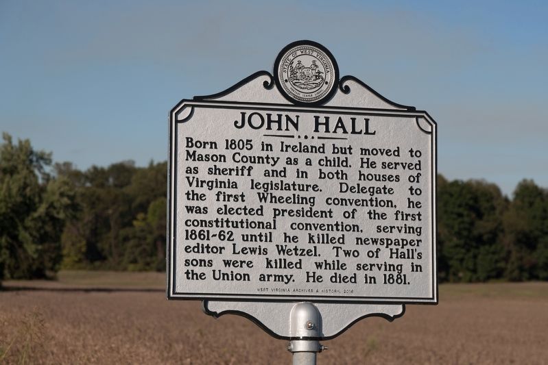
Inscription: Born 1805 in Ireland but moved to Mason County as a child. He served as sheriff and in both houses of Virginia legislature. Delegate to the first Wheeling convention, he was elected president of the first constitutional convention, serving 1861-62 until he killed newspaper editor Lewis Wetzel. Two of Hall’s sons were killed while serving in the Union army. He died in 1881.
Location: WV 62, north of Point Pleasant
Title: Daniel Haymond Polsley
Blog Link: Coming Soon

Inscription: Born 1803 in Palatine, Polsley was a noted lawyer and publisher of the Western Transcript in Wellsburg until he moved to Mason County in 1845. A delegate to the Wheeling conventions, Polsley served in the Restored Government of Virginia as lieutenant governor. Circuit judge, 1863-1866, he served one term in the U.S. House, 1867-1869. Polsley died at home on October 14, 1877.
Location: WV 62, Point Pleasant
Title: Kellian V. Whaley
Blog Link: Coming Soon

Inscription: Born May 6, 1821, Whaley served as a Union recruiter and colonel in the 9th WV Volunteer Infantry. He was captured November 10, 1861, in Guyandotte during the battle there but escaped. First elected to the U. S. Congress in 1861, in 1863 he became one of the first three men to represent the new state of WV in Washington, DC. Whaley died in Point Pleasant on May 20, 1876.
Location: WV 62, Point Pleasant
Title: William H. Powell
Blog Link: Coming Soon

Inscription: Born 1825 in Wales, he emigrated to U.S. as a child and was working in iron industry when war erupted. Commissioned captain of 2nd (West) Virginia Cavalry at Ironton, OH and won Medal of Honor for actions at Sinking Creek Valley in 1862. Wounded, captured and imprisoned, 1863, and released, 1864. Brevetted major general late in war. He died in 1904 and was buried in Chicago.
Location: WV 62, Clifton
